


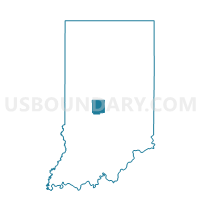
WASHINGTON 18, Hendricks County, Indiana
About
Outline

Summary
| Unique Area Identifier | 577701 |
| Name | WASHINGTON 18 |
| County | Hendricks County |
| State | Indiana |
| Area (square miles) | 0.40 |
| Land Area (square miles) | 0.39 |
| Water Area (square miles) | 0.01 |
| % of Land Area | 97.61 |
| % of Water Area | 2.39 |
| Latitude of the Internal Point | 39.77002590 |
| Longtitude of the Internal Point | -86.34491250 |
Maps


Graphs
Select a template below for downloading or customizing gragh for WASHINGTON 18, Hendricks County, Indiana


Neighbors
Neighoring Voting District (by Name) Neighboring Voting District on the Map
- WASHINGTON 03, Hendricks County, IN
- WASHINGTON 19, Hendricks County, IN
- WASHINGTON 23, Hendricks County, IN